Jain Remains of Ancient Bengal
by Shubha Majumder | 2017 | 147,217 words
This page relates ‘Geographical as well as Geo-political unit of Zone II’ of the study on the Jain Remains of Ancient Bengal based on the fields of Geography, Archaeology, Art and Iconography. Jainism represents a way of life incorporating non-violence and approaches religion from humanitarian viewpoint. Ancient Bengal comprises modern West Bengal and the Republic of Bangladesh, Eastern India. Here, Jainism was allowed to flourish from the pre-Christian times up until the 10th century CE, along with Buddhism.
Geographical as well as Geo-political unit of Zone II
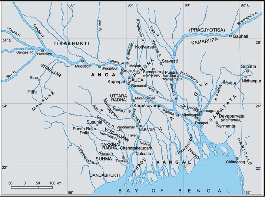
The ancient geographical units to which the present zone belonged, was known as Vaṅga though this zone often became a part of Suhma[1] (Fig.2.8). It occupied the southern part of Bengal and geographically, it is constituted by the Ganga Delta proper, which can be further sub-divided into the moribund, mature and active (Spate and Learmonth 1984: 588.), or the moribund, immature, mature and active deltas (Rashid 1991: 29·34).
The name Vaṅga is clearly referred to in the Baudhāyana Dharmasūtra (1.1.: 25-31), the Purāṇas (Mārkaṇḍeya Purāṇa: 325n.), the Arthaśāstra of Kauṭilya (II: 11), the Mahābhārata (VII. 9, 15), the Rāmāyaṇa (II, 10. 36-37), Buddhist texts (Aṅguttara Nikāya, I, XIV, 3), the Mahābhāṣya of Patañjali (II, P. 282) and other literary texts. Among these textual references the Arthaśāstra of Kauṭilya (II: 11) is the earliest reference from where Vaṅga is mentioned as a territorial unit. However, none of the texts mentioned above help us to identifying the geographical denotation of the term Vaṅga (Bhattacharyya 1977: 56).

Figure 2.8. Map showing the different ancient Geo-political unites of ancient Bengal
The Raghuvaṃśa of Kālidāsa (IV: 36; Kale 1922) gives some ideas about the geographical bearing of Vaṅga. It mentions that after having defeated the Suhmas, Raghu exterminated the Vaṅga and set up pillars of victory in the island situated within the streams of Ganges. According to this description, we can assume that the western boundary of ancient Vaṅga lay on the course of the Adi Ganga and that Suhma was further to the west. Again the Jain Upāṅga Prajñāpana mentions Tāmralipta as falling within the territorial unit of Vaṅga (Smyth 1891: 375; Raychaudhuri 1987: 15-16). Ancient Tāmralipta is identified with modern Tamluk in the East Midnapur district. Several scholars have identified ancient Tamralipta with Pliny’s Taluctae and Ptolemy’s Tamalites/ Tamilites. The Periplus (1st century CE) states that from a market-town known as Gange (again identified with ancient Tamralipta) pearls, muslins, spikenard and malabathrum were exported to the other countries. In the Jain Kalpa-Sūtra, Tāmraliptikā is mentioned as one of the Jain ascetic orders (Ramachandran 1951: 226). The Abhidhāna-Cintāmaṇi cites Dāmalipti, Tāmalipta, Tamālinī, Stambapura and Visṇugṛha as synonyms of Tāmralipti. The Trikāṇḍaśeṣa adds Velākūla and Tamālika (Raychaudhuri 1978: 30). In the Jain text Samaraiccha Kaha, Tamralipti is known as an important port-town for journeys to Southeast Asia and Sri Lanka and the most important centre of inland as well as foreign trade (Shukla 1996). The Bṛhat-Saṃhitā of Varāhamihira, a 6th century CE text, refers to Gauḍaka as a part of Bengal which is distinguished not only from Pauṇḍra, Tāmraliptika, Vaṅga, Samataṭa but also from Vardhamāna (ibid: 13).
According to the Chinese pilgrim Xuanzang, who visited this region about 638 CE, Jainism was one of the dominant religions. Perhaps the ancient port town of Tāmralipta was frequented by Jain traders who originally hailed from Mathura, Kasi, Varanasi, Rajagriha, Champa and other major centres of the middle Ganga Plain. In this context we may narrate the story of the three brothers–Udayamāna, Śrīdhautamāna and Ajitamāna–who went on business from Ayodhyā to Tāmralipta and made plenty of money. This is mentioned in the Dudhpani rock inscription from Hazaribagh district. This undated inscription has been assigned on palaeographical grounds to about the 8th century CE (Kielhorn 1984: 343-7).
Apart from Tāmralipta, there are a large number of archaeological sites (both early historic and early medieval) in the Vaṅga territory and this name was mentioned even in the 13th century Madanpada Copper-Plate inscription of Viśvarūpasena (Majumdar 1929: 132-39; Sircar 1954: 209-17) though there is ambiguity regarding the geographical boundary of Vaṅga. Jain antiquities are well reported from this zone. In this context it is worth mentioning that this coastal line zone which extends up to present Bangladesh is not included in the preview of the present research. Till today not a single Jain antiquity has been reported from this area. This zone is known as Samataṭa and the geography of Vaṅga was closely connected with that of Samataṭa (Sen 1942: 89 and f.n. 3)[2] . This is another administrative unit in ancient Bengal and is referred in the Allahabad Pillar inscription of Samudragupta. This semiindependent feudatory state was gradually incorporated in to the Gupta Empire during the 6th century CE (Majumdar, 1971: 48-50).
Footnotes and references:
[1]:
In this context an observation made by Dilip K. Chakrabarti should be noted—“In the context of ancient India the meaning of such geographical terms is always a little imprecise because the texts and inscriptions which mention them are mostly silent on their physical boundaries. However, the general bearings are usually clear enough” (2001: 153).
[2]:
Samataṭa is located at the eastern fringe of Bengal, with sub-regions of Śrīhaṭṭa and Harikela respectively on its northern and southern sides. Geographically, it is a low land constituted by a delta and floodplains made by the activities of the rivers Surma and Meghna, and Tippera surface, with low hill range of Lalmai on its eastern end (Rashid 1991: 28-29, 36) corresponds to the depression called Haor basin in present Sylhet division (ibid.:24-26.), while Harikela corresponds to the coastal region of the present Chittagong district (Bhattacharyya 1977:.69-70). Meghna River constitutes the border between Samataṭa and Vaṅga (ibid.: 67), while its border with Srīhaṭṭa and Harikela is not so clear. Hemachandra used Vaṅga and Harikela as synonymous term in his Abhidhāna Chintāmaṇi (IV 23).
In this context it is to be mentioned that though the Samataṭa region has experienced a long settlement history, paucity of data during these days never allows us to place it within a specific administrative jurisdiction.
