Jain Remains of Ancient Bengal
by Shubha Majumder | 2017 | 147,217 words
This page relates ‘Geographical Setting of Zone I’ of the study on the Jain Remains of Ancient Bengal based on the fields of Geography, Archaeology, Art and Iconography. Jainism represents a way of life incorporating non-violence and approaches religion from humanitarian viewpoint. Ancient Bengal comprises modern West Bengal and the Republic of Bangladesh, Eastern India. Here, Jainism was allowed to flourish from the pre-Christian times up until the 10th century CE, along with Buddhism.
Geographical Setting of Zone I
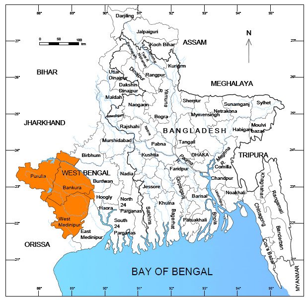
This zone, covering the present districts of Purulia, Bankura, western part of Burdwan and West Midnapur, is actually the eastern extension of the Chhotanagpur plateau (Fig. 2.6). Geographically, it is constituted by lateritic old alluvium flanked by the coalesced fans of rivers Ajay, Damodar, Rupnarayan and Kasai, and the moribund and mature deltas along BhagirathiHoogly River (Morrison 1970: 152). It is bordered by the Rajmahal and Chhotanagpur hill tracts on the west and the uneven plateau land gradually merging with the plains in the east. Geo-morphologically, the region mainly presents rugged topography in the form of denudational hills and ridges though sometimes it is also interrupted by lateritic upland formed of laterised boulder conglomerate of Middle Pliestocene age (Chattopadhyaya et.al. 2005: 29). The mineral deposits consist mainly of iron, coal, copper, lead, gold and others, amongst which, iron ores are found in profuse quantity. This western plateau and the rolling uplands are mainly formed of granite and gneiss found in Ayodha, Mama Bhagne and Biharinath hills whereas a sizable proportion of lateritic soil mixed with kankar constitutes the remaining part (ibid.: 21).
The rivers in this zone are seasonally torrential though they turn dry in the summer. All the rivers of this zone, excepting the Sarasvati, originate from the Chhotanagpur plateau and run in a south-easterly direction. Gradually they merge into the Bhagirathi with gently flattish river beds. The major rivers are Ajay, Damodar, Dwarakeshwar, Kangsabati, Kumari, Rupnarayan and a large number of minor rivers.
The river Ajay rises in Munger district of Bihar and flowing towards the south-east forms the dividing line between Burdwan and Birbhum districts of West Bengal. In the present zone the Asansol and Durgapur sub-divisions, which are situated to the west of Ajay, are incorporated. A number of early medieval archaeological sites associated with Jain antiquities have been documented from this area.

Figure 2.6. Map showing the zone I of the present study area (with colour)
The most important river of the western plateau emanating from the Chhotanagpur area is the Damodar. This river originates in the hills of the Rajruppa in District Ranchi, Jharkhand. After entering West Bengal, the river attains its maximum width in Burdwan and forms the core of the Damodar valley. The archaeological geography of the entire central-central-western tracts of West Bengal is controlled by the current flow of the Damodar. The upper, middle and lower valleys of the Damodar have experienced the growth of a large number of noted proto-historic and historical settlements of West Bengal, chronologically ranging between the late second millennium BEC and early second millennium CE. So far as, in the present zone we are concerned only with the upper and middle valleys of the Damodar river. Both the left (western, south-western parts of Burdwan) and right (northern, north-western and north-eastern parts of Bankura) banks of the river Damodar form a major archaeological settlement zone with rich distribution of archaeological sites. We have documented a good number of archaeological sites associated with Jain antiquities (both temples and sculptures) from this area.
The river Dwarakeswar rises from the Chhotanagpur plateau and thereafter it crosses the northern part of Purulia and flows in the southeastern districts across the town of Bankura. Near Ghatal in East Midnapur it joins the Silai, another small though important river in the present zone. The combined stream flows on under the name Rupnarayan. This river valley along with the middle Damodar river valley create one of the most important archaeologically potential zone which witnessed a long chrono-cultural development from prehistoric times to the present. The valley witnessed the earliest experience of village farming cultures in eastern India assignable to the middle of the second and the first millennium BCE [as attested by the radio carbon dates from the excavated site of Dihar (Chattopadhyay et. al. 2014-15: 97) in the Dwarakeswar valley]. From the ninth century onwards, the socio-historical tendencies of this area reflected the popularity of Jain ideology as apparent from the abandoned structural relics, extant temples, stone images, other settlement ruins/remains scattered with potsherds and other minor antiquities of this period found from several archaeological sites. However, in the medieval period, sculptural and architectural remains associated with Brahmanical ideology show a marked increase.
In the context of Jainism, the river Kasai/Kansavati played an important role and we find that most of the villages along this river valley, in the districts of Purulia and Bankura, bear Jain affinity as seen from the abandoned temple complexes as well as Jain sculptural specimens. The river Kansavati originates from a hill in the Jhalda region and it passes through Purulia district, Khatra and Ranibandh in Bankura district and then enters West Midnapur through Binpur and finally merges with the river Bhairab banki. The antiquity of this river is also attested by the Raghuvaṃśa of Kalidāsa (Bhattacharya, ed. 1961: 23). Kalidāsa refers to a river called Kapiśā and Raghu crossed over this river to Utkala. The river Kapiśā probably served as an eastern boundary of Utkala and at present is identified with Kansai. However, there are different views.
Further south the river Subarnarekha flows that rises from the hilly areas of the Chhotanagpur plateau, and then enters the district of West Midnapur. The river forms the boundary between West Midnapur and Orissa in south-west West Bengal. The archaeological horizon represented by the sites along the Subarnarekha reflects an expansion of settlements of early historic to early medieval periods, though the possibility of an antecedent phase of sedentary rural development is also logical, as suggested by the recent excavations at the site of Moghalmari (Datta 2008). Jain antiquities are also reported from this area along the Subarnarekha river valleys in the West Midnapur district. The different river valleys in zone I are a major factor for the growth and spread of Jain ideology during the early medieval period.
